Análise espacial
x
x
Por: Eduardo Ascensão
e Miguel Leal, 2019
e Miguel Leal, 2019
Based on the cartography we developed in the project, which was the base for the PER Atlas, here we show the implementation of the PER from a specific angle, that of its spatiality and the location of rehousing within the city.
The geo-referencing of the approximately 30,000 dwellings surveyed in the LMA in 1993 allowed us to study the transfer of populations across the metropolitan space, from informal settlement to rehousing estate. This was a research lacuna on the PER and it tells us a number of things regarding the different municipalities’ implementation models as well as regarding the populations’ right to the city. We discuss them below.
From informal settlement to housing estate: the many rehousing paths in the Lisbon Metropolitan Area. Maps by Miguel Leal.

The PER in the Lisbon Metropolitan Area
In the late 1980s, around 200,000 people lived in informal settlements in Portugal
(AML, 1997; Ascensão 2015: 52). This was at the peak of a long process of internal migration to the Porto and Lisbon metropolitan areas since the 1960s, and immigration
to Lisbon since the mid-1970s from Portuguese-speaking African countries (former colonies) such as Cape Verde, Guinea-Bissau, Angola, Mozambique and São Tomé and
Príncipe. The most vulnerable populations had been priced out of the housing market and left out of the eligible pool for the diminutive public housing system; in effect they
had been ‘led’ to the interstices of the urban fabric to look for or build the accommodation they could not find or afford in the regular city. Informal settlements
were then tacitly accepted by the state because of its inability to provide decent housing for everyone. (Salgueiro, 1977; Rodrigues, 1989; Malheiros and Vala, 2004;
Nunes and Serra, 2004; Pinto 2009).The settlements varied greatly in size, morphology and location in the metropolitan area. Although their average size in number of dwellings was of 33 shanty dwellings per settlement (32,333 dwellings divided by 984 settlements), they could range from large settlements with four or five hundred shack dwellings, located next to industrial or commercial areas where their residents worked, to small pockets of 5 to 20 shanties in municipal hinterlands, which were almost ad hoc rural settlements; with many other forms and sizes in between.
The Quinta de Calvanas settlement in Lisbon (top), Quinta da Vitória in Loures (center) and Beco dos Pombais in Oeiras (bottom), c. 1990. Sources: C.M. Lisboa, C.M. Loures and C.M. Oeiras.

In some cases the settlements were contiguous (e.g. Bairro 6 de Maio, Estrela de África and Fontaínhas in Amadora), making for areas with more than a thousand shanty dwellings (and 3-4 thousand people inhabiting them). The table below identifies the 20 largest settlements in terms of number of households. It tells of the relative
importance of the largest settlements, i.e. how 2% of the settlements housed 36,5% of the slum dweller population.

In 1993, the PER was initiated by the central government, with the National Housing
Institute and municipal governments having the duty to implement it, in what was to
be a significant element of broader processes of urban restructuring of the Lisbon and
Porto metropolitan areas. In Greater Lisbon, for instance, the PER involved the transfer
of the population residing in 984 small and medium settlements to 290 dedicated
public housing estates. In total, the program built around 45,000 new dwelling units
(Santos et al 2015). 1 However, in many cases the implementation of the PER was
beset by the inexistence of public land near the original settlements needed to accommodate in situ rehousing. Coupled with municipal authorities’ financial
constraints (despite central government covering 50% of the costs of building new
housing estates), this resulted in the displacement of populations to far-away sites and
the disruption of existing social and labour networks. We provide glimpses of this
process further below.
Perspectives on the PER
Before, we briefly introduce some of the research conducted on the PER. At the
beginning of the program, a number of academic publications coming from LNEC’s
Social Ecology Group focused on the social needs of households to-be-rehoused (Pinto
1994, Freitas 1994) but they were mostly preoccupied with guidelines for good
rehousing and included elements of socio-ecological determinism (e.g. advising certain
architectural features for particular populations such as Gypsies) that rendered them
quite dated as the years passed. Immediately after, academic research centers such as
CET-Centro de Estudos Territoriais (Loures) or SociNova (Oeiras) were contracted by
different municipal governments to help, as consultants or prime movers, to survey
the settlements, in order for implementation to be a precise and scientifically-
informed administrative procedure. These collaborations ranged from the sociological
studies of SociNova to the rigid census-like surveying of CET (e.g. Marques et al 2001,
Dinamia CET 1992). At approximately the same time, rich urban histories of some of
the oldest settlements with very particular trajectories, such as the then ‘drug quarter’
Casal Ventoso in Lisbon, were produced by young social science researchers (Chaves
1999). The PER also appeared as an explanatory factor in research on residential
segregation. For instance Malheiros and Vala (2004: 1079-80) noted a reduction in the
segregation levels of immigrants from Portuguese Speaking African Countries in the
2001 Census and pointed to the PER as a possible explanation, but curiously their work
also showed such population group was still over-represented in the ‘inhabiting slums
or ‘inhabiting overcrowded dwellings’ categories, even after a good part of the PER
estates had been built, leaving open the question of whether the program had in fact
helped reduce segregation or, alternatively, reinforce it. Later, in the 2010s, critical
studies pointing to the way the type of governmentality the program instituted (with
non-participated decisions, the atomization of communities and even households,
eligibility controversies, forced evictions, displacement to far-away sites, loss of labour
and social networks) was experienced by target populations started to appear
(Cachado 2013, Ascensão 2013, Sampaio 2013, Pozzi 2017), but their monographic
nature meant they focused on a limited number of sites and could thus be put aside as
negative cases not illustrative of the whole program. Interestingly, no complete survey
or record of where all the 984 informal settlements stood in the LMA, nor of the 290
housing estates built in order to rehouse people, was produced. This is what we tried
to do, having in mind it could be a crucial tool to shed light on the way the PER can be
argued to have been an integral part of a broader process of uneven urban
restructuring.The displacing effects of the PER
The PER involved both in situ rehousing (with apartment blocks built on the sites of the
previous informal settlements) and clearance and re-housing in more peripheral,
segregated and underserviced housing estates across the metropolitan area. For
instance the Marianas-Adroana (in the municipality of Cascais), Azinhaga dos
Besouros-Casal da Mira (Amadora) or Pedreira dos Húngaros-Moinho das Rolas
(Oeiras) transfers were among the latter cases. A third set of controversial transfers
involved the even more complicated cases where the squatted land was privately-
owned and local governments failed to expropriate it in timely fashion: the original
privileged locations were earmarked for private residential development for the white
middle classes and the mainly black immigrant poor populations were displaced to
scattered destinations, through the PER-Famílias or ad hoc arrangements (Ascensão
2015).Dispossession of privileged location in Cascais: the Marianas settlement in 1995 (left), the Adroana housing estate (top right) and the redevelopment of Marianas-Carcavelos (bottom right) in 2017. Sources: LNEC 1995 and E. Ascensão.

The question is to what degree this happened across the metropolitan area and within
municipal boundaries. How many people stayed on site, how many moved, where they
moved to and what was the average distance covered with the transfer? There are
other relevant elements to analyse the PER, but here we focus on the most simple of
indicators, location. Location is a clear indicator of urban restructuring processes that
require the uprooting of particular communities from their living space, and thus a
crucial element to measure urban dispossession. Furthermore, the centrality of
location in terms of urban social justice was not lost on the experts and the housing
milieu involved in the PER’s design as a public policy, and that was one of the reasons
the legal figure which enacted the PER stated very clearly in its article 5, c) that City
Councils had to:
“Assure that land currently occupied by shanty settlements to be demolished which is the property of, or is in possession of, municipal authorities and is zoned as residential [housing] should be directed to the program’s implementation or to the provision of controlled cost housing.” (Decree-Law 163/93)
It was a clear option for in situ solutions and a nod to the Portuguese derivative of the right to the city dating back to the post-revolutionary housing program SAAL, the right to the place (direito ao lugar). Dislocation vs the right to stay put is not a perfect indicator to measure an entire process of urban restructuring. In abstract terms, spatial dislocation does not equate purely with dispossession, for instance in the cases where a) the second location is also a privileged one; b) has at least the potential for people to re-enact their original job and social networks in the new place of inhabitation; or finally c) if improved tenure status can balance the negative effects of displacement. However, monographic cases have established that for the PER such cases are but a minority. Thus we take dislocation as a good proxy indicator for a complex process that stretches beyond mere travels across metropolitan space.
The first important thing the cartography illuminates is a configuration of displacement patterns clearly contained in discrete geographical boundaries, those of the municipalities. Although obvious as the program was delegated to City Councils for its implementation, it still gives a remarkable image of how administrative and planning boundaries shape metropolitan-wide programs.
“Assure that land currently occupied by shanty settlements to be demolished which is the property of, or is in possession of, municipal authorities and is zoned as residential [housing] should be directed to the program’s implementation or to the provision of controlled cost housing.” (Decree-Law 163/93)
It was a clear option for in situ solutions and a nod to the Portuguese derivative of the right to the city dating back to the post-revolutionary housing program SAAL, the right to the place (direito ao lugar). Dislocation vs the right to stay put is not a perfect indicator to measure an entire process of urban restructuring. In abstract terms, spatial dislocation does not equate purely with dispossession, for instance in the cases where a) the second location is also a privileged one; b) has at least the potential for people to re-enact their original job and social networks in the new place of inhabitation; or finally c) if improved tenure status can balance the negative effects of displacement. However, monographic cases have established that for the PER such cases are but a minority. Thus we take dislocation as a good proxy indicator for a complex process that stretches beyond mere travels across metropolitan space.
Many Xs, many Ys: dispersing communities within municipal boundaries
The first important thing the cartography illuminates is a configuration of displacement patterns clearly contained in discrete geographical boundaries, those of the municipalities. Although obvious as the program was delegated to City Councils for its implementation, it still gives a remarkable image of how administrative and planning boundaries shape metropolitan-wide programs.

The image also shows how despite the several arguments City Councils had between
themselves over PER populations ‘belonging’ to one moving to the other (such as
Sintra’s discomfort with Lisbon or Amadora buying apartments within its boundaries to
rehouse several PER households [Interview with Councilman, October 2018]),
essentially each municipality implemented the PER within its territory and following its
own procedures. This raises the question of a program devoted to rehousing in
metropolitan areas being carried out in a much smaller scale, thus losing a potentially
beneficial ‘metropolitan dimension’.
The second element that stands out is how data, in GIS terms, amounts to a large number of Xs (origin) and a large number of Ys (destination). A good illustration regards the Oeiras municipality, with an almost incomprehensible array of displacement paths if one looks at all the paths taken by the over 5000 households eligible for the program.
The second element that stands out is how data, in GIS terms, amounts to a large number of Xs (origin) and a large number of Ys (destination). A good illustration regards the Oeiras municipality, with an almost incomprehensible array of displacement paths if one looks at all the paths taken by the over 5000 households eligible for the program.

All the household paths in the Oeiras municipality. Source: Oeiras City Council (CMO – Câmara Municipal de Oeiras).Rehousing paths in the Oeiras municipality, more than 10 households. Source: Oeiras City Council (CMO – Câmara Municipal de Oeiras).

Indeed, only by taking out those with less than 10 households does a clearer image
arise. In the case of Oeiras, what this means is that there was a break-up of established
communities in a large majority of the original informal settlements (48% of
settlements have 4 or more destinations, increasing to 80 % for those with more than
10 households and 93 % for those with more than 20 households – the exceptions
being Leceia and Parque das Merendas), but also that housing estates have very mixed
populations in terms of settlement of origin (out of the 24 housing estates, 14 (58%)
have more than 10 origins, but the remaining ones are very small in number of
dwellings). Among the largest estates, it is common for them to have population
coming from 34 (Pombal), 33 (Páteo dos Cavaleiros), 25 (Moinho das Rolas), 25 (São
Marçal), 22 (Encosta da Portela) or 21 (Francisco Sá Carneiro) different origins. It
explains why for 71 informal settlements and 24 housing estates, 345 different
transfers existed within the municipality (average of 4.9 destinations for each
settlement).
In its simplest form, such type of process can be represented this way:

where ‘a’ and ‘b’ stand for informal settlements and capital letters for new estates. Instead of a and b going to A, or each going to their corresponding estate, both were dispersed; and both estates have a mixed population. This tallies with testimonies from municipal workers familiar with the PER in Oeiras, which admitted that ‘there was a deliberate policy of dispersal, as it was judged to be a positive feature’ (municipal officer, Jan. 2017). So what we have is a process of deep restructuring within municipal boundaries, combining displacement with dispersal. Take one of the largest settlements, Pedreira dos Húngaros. Its 602 households were rehoused in 17 different destinations across the entire municipality, with the three largest contingencies going to Navegadores (158 households), Páteo dos Cavaleiros (141), both within the municipality’s public housing ‘deposit area’ - areas with a extremely high percentages of public housing – Portela-Outurela; and the third (79 households) travelling 7 km West to the Moinho das Rolas estate, next to the Lagoas Office Park.
In its simplest form, such type of process can be represented this way:
where ‘a’ and ‘b’ stand for informal settlements and capital letters for new estates. Instead of a and b going to A, or each going to their corresponding estate, both were dispersed; and both estates have a mixed population. This tallies with testimonies from municipal workers familiar with the PER in Oeiras, which admitted that ‘there was a deliberate policy of dispersal, as it was judged to be a positive feature’ (municipal officer, Jan. 2017). So what we have is a process of deep restructuring within municipal boundaries, combining displacement with dispersal. Take one of the largest settlements, Pedreira dos Húngaros. Its 602 households were rehoused in 17 different destinations across the entire municipality, with the three largest contingencies going to Navegadores (158 households), Páteo dos Cavaleiros (141), both within the municipality’s public housing ‘deposit area’ - areas with a extremely high percentages of public housing – Portela-Outurela; and the third (79 households) travelling 7 km West to the Moinho das Rolas estate, next to the Lagoas Office Park.

The path of the 79 households who were rehoused 7 km away illustrates well a
symptomatic solution that urban restructuring of this kind has for urban poor
populations and it raises questions regarding the future labor trajectories of these
populations, in the sense that being caught in a segregated, distant urban trap may
equate to being caught in a poverty trap.
Such questions also apply, though differently, to the two other large contingencies of Pedreira dos Húngaros inhabitants, which were moved to Outurela-Portela, one of the ‘deposit areas’ for public housing (areas with an extremely high percentage of public housing) in Oeiras. Although nearer the original settlement than Moinho das Rolas, Outurela-Portela features six different public housing estates from different eras (from the SAAL to municipal CDHs to the PER) amidst several industrial and warehouse facilities and, since the late 2000s, a large shopping mall and an Ikea store, all circumscribed by motorways and access ways, making it a confined and socially segregated area with difficult public transportation to the rest of the city.
To conclude, the Oeiras municipality, although often cited as a success case of the PER and having started the provision of social housing for slum dwellers before the PER was enacted, instituted a complex movement of people across its space, combining dispersion with displacement to new estates with a high concentration of poverty. From the viewpoint of populations, it involved three different things they had to adapt to quickly, without much of a say so: the uprooting from one location to another; the splintering of their established community; and insertion into a new setting with other poor populations coming from very different places.
The case of Almada contrasts with Oeiras regarding its implementation model. In the municipality and according to current data, for 29 informal settlements and 12 housing estates, only 37 different transfers existed within the municipality, producing a much smaller average of 1.2 destinations for each settlement.
Such questions also apply, though differently, to the two other large contingencies of Pedreira dos Húngaros inhabitants, which were moved to Outurela-Portela, one of the ‘deposit areas’ for public housing (areas with an extremely high percentage of public housing) in Oeiras. Although nearer the original settlement than Moinho das Rolas, Outurela-Portela features six different public housing estates from different eras (from the SAAL to municipal CDHs to the PER) amidst several industrial and warehouse facilities and, since the late 2000s, a large shopping mall and an Ikea store, all circumscribed by motorways and access ways, making it a confined and socially segregated area with difficult public transportation to the rest of the city.
To conclude, the Oeiras municipality, although often cited as a success case of the PER and having started the provision of social housing for slum dwellers before the PER was enacted, instituted a complex movement of people across its space, combining dispersion with displacement to new estates with a high concentration of poverty. From the viewpoint of populations, it involved three different things they had to adapt to quickly, without much of a say so: the uprooting from one location to another; the splintering of their established community; and insertion into a new setting with other poor populations coming from very different places.
A gradual approach: shorter displacement paths and keeping communities together
in Almada
The case of Almada contrasts with Oeiras regarding its implementation model. In the municipality and according to current data, for 29 informal settlements and 12 housing estates, only 37 different transfers existed within the municipality, producing a much smaller average of 1.2 destinations for each settlement.
The 37 rehousing paths in the Almada municipality. Source: C. M. Almada).
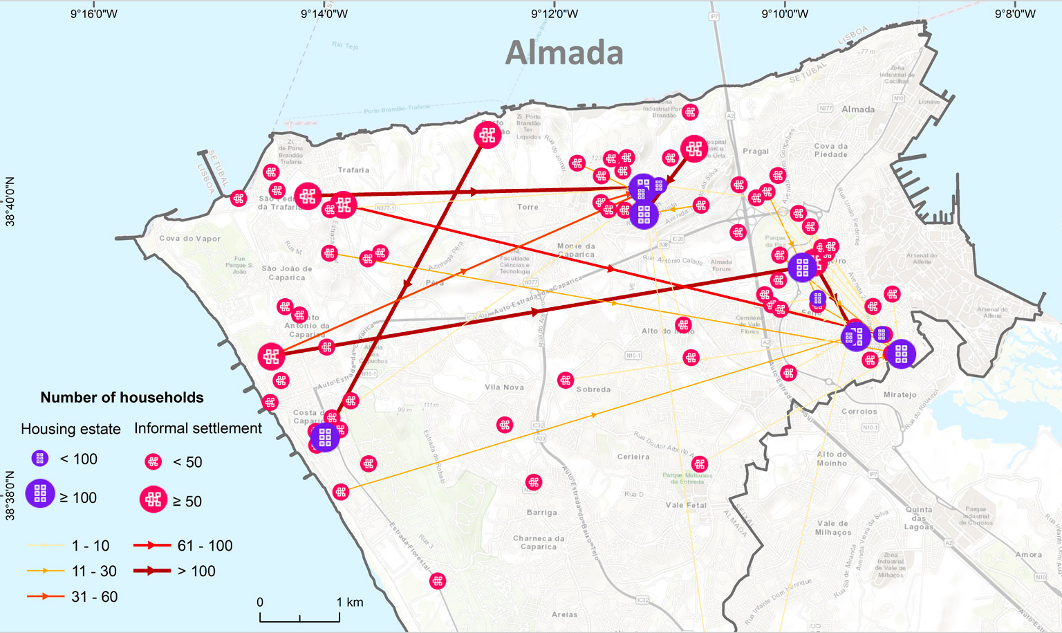
This means that the Almada City Council opted, with minor variations, to preserve the
same populations upon rehousing. For instance the 114 households living in the
Valdeão settlement near what today is a large hospital were all rehoused to the Monte
da Caparica estate 500 metres away. Likewise, the 179 households living in Asilo 28 de
Maio were all rehoused in Urbanização Nossa Senhora da Conceição, although this
scheme was implemented by Casa Pia, a centenary welfare association. Other paths
are longer, but overall there is a sense that displacement and especially dispersion
were minimized. Furthermore, many estates are located amidst Pragal, Almada and
Cova da Piedade’s functional areas, so people stayed near jobs and services. This
positive trait in a way balances out the accepted knowledge that PCP (Portuguese
Communist Party)-run local governments such as Almada or Loures were reluctant to
provide swift rehousing solutions as the national party’s policy was that housing is
constitutionally dictated to be a responsibility of central government. This partly
explains why even today Almada still has cases to be solved such as Segundo Torrão,
with 287 households registered to be still on site, but when it implemented the PER it
did so with a model that seemingly tried to preserve communities and access to jobs
and services.
This leads us to the different models of implementation municipalities followed.
There are many different particularities to each of the LMA’s 19 local governments implementation of the PER, but looking at the way people were rehoused across the metropolitan space gives us a condensed overview of those models. For example, below we see the case of Montijo, which is one of the clearest cases of concentration, i. e. of households living in settlements in several different locations being rehoused in one or two housing estates. There, households living both in shacks in peri-urban areas and in pátios (inner courtyard tenements) in the town centre were rehoused to the Esteval and Esteval Novo housing estates, slightly towards the periphery. Regardless of how one sees such model (as positive or negative), the data allows to see that there was a clear concentration of PER households.
Models of implementation
This leads us to the different models of implementation municipalities followed.
There are many different particularities to each of the LMA’s 19 local governments implementation of the PER, but looking at the way people were rehoused across the metropolitan space gives us a condensed overview of those models. For example, below we see the case of Montijo, which is one of the clearest cases of concentration, i. e. of households living in settlements in several different locations being rehoused in one or two housing estates. There, households living both in shacks in peri-urban areas and in pátios (inner courtyard tenements) in the town centre were rehoused to the Esteval and Esteval Novo housing estates, slightly towards the periphery. Regardless of how one sees such model (as positive or negative), the data allows to see that there was a clear concentration of PER households.
Montijo’s concentration model.

In contrast, Oeiras as we have seen above is an illustration of the model of dispersion,
as in its own way is Cascais. The map below shows how the informal settlements located across the coast line gave way to rehousing further North, reproducing the
municipality class divide that sees richer populations concentrated on the coast line
being served by lower income populations who live further inland. Although some of
the paths are less pronounced than others, overall this northwards peripheral
movement is clearly discernible. In addition, the largest informal settlements (those
with at least 10 households) have an average of 9.6 fluxes, meaning households of
such settlements were rehoused on average in 9.6 different places (compared for
instance with Almada’s ratio of 1.2), which gives yet another indication of dispersal.
Cascais as an exemplar of the dispersal model.

Then, there are hybrid models such as Odivelas, where different dynamics co-exist:
there is a concentration of a large number of households in a public housing estate
North of the city centre, but also rehousing in the Southern areas close to Lisbon and
the metro stops. This is partly due to the municipality’s particular spatial configuration
(the centre and the latter areas constitute the municipality’s two centralities) but there
was also a mix of options (between concentration and dispersion) being followed.
Odivelas: an hybrid model.

Finally, there is the case of Lisbon, where the absence of public housing in the central
part of the city is clearly visible, with the exception of the Graça estate (often used to
counter the reports which point out such absence). This is partly explained because of
the lack of vacant public land where PER estates could be build, although for the
middle classes some schemes in the centre were devised, using the rehabilitation of
older buildings for the effect. Another recurrence is the existence of dense ‘deposit
areas’ such as Chelas and Alta de Lisboa, to where many rehousing paths converge.
Rehousing paths in Lisbon.

However, what stands out the most is the contradiction between what is visually
perceptible from the data and how politicians and experts perceive the policy:
“Our policy was always to rehouse populations in the place where they lived.” (Councilman, head of rehousing, Sep. 2018)
It is true that many estates were built near the original settlements, so the above excerpt is not a disingenuous camouflage of a harsher policy but rather one that would seem to tally, at first sight, with reality. However, in situ solutions did not mean that there were no transfers across the city space, as is easily discernible visually and is reinforced by the fact that 80% of rehousing paths have more than 1 km, a significant distance for the scale of Lisbon.

Of course there is a difference between macro-level policy tenets (‘we will build in the
sites of the original settlements or nearby’) and their implementation at the micro-
level (‘family x goes here, family y goes there’); and municipal governments in Portugal
have very often tended towards authoritarian or at least non-participated decisions
when it comes to urban poor populations, directing them to where they see fit. Was
that the case here? The considerable movement of people across Lisbon’s urban space
despite estates being built near the original sites seems to point to an implementation
that did not understand the policy’s basic tenet. But it could also be related to other
factors that only a qualitative and detailed case study would illuminate – and are thus
not in the remit of this essay. The fact remains, rehousing in Lisbon saw an extensive
movement of people across the city, leaving open the questions of how disruptive this
was to people’s social networks and the extent to which this meant the freeing up of
privileged locations.
One of the ways to answer these questions and to densify analysis was simply to look at what substituted the settlements. We looked at the larger 100 settlements in the LMA and categorised what presently exists on site.
One of the ways to answer these questions and to densify analysis was simply to look at what substituted the settlements. We looked at the larger 100 settlements in the LMA and categorised what presently exists on site.
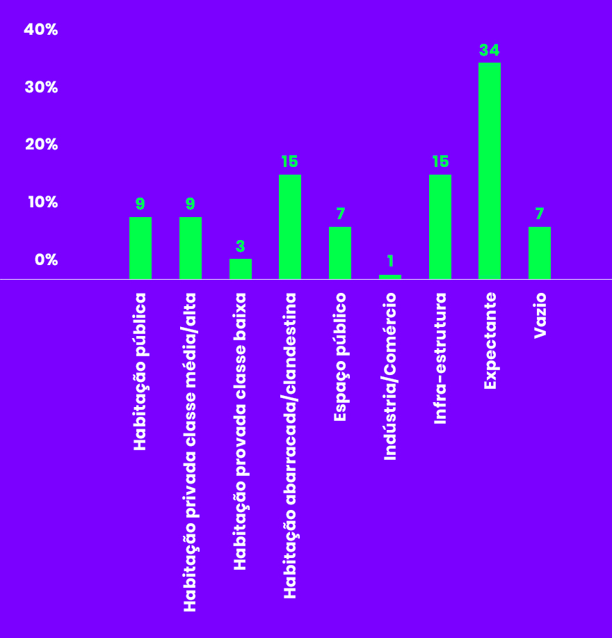
There is an equal measure of 9 percent for ‘public housing’ (typically for the most
vulnerable populations) and ‘private housing for middle/upper- middle classes’, with a
less significant 3 percent of ‘private housing for lower/lower-middle classes’. In all,
only 21% of the settlement sites are dedicated to housing, rising to 36% if we consider
the 15% that are still constituted by ‘shack-like’ (abarracada) or illegal housing.
Clearance for infrastructure constituted a significant 15% (the cases that spring to
mind are Amadora’s Fontaínhas or Azinhaga dos Besouros making way for the CRIL ring
road and its access ways). Finally, the most significant category groups together the
34% of expectant sites, joined by the 7% corresponding to ‘void’ areas, i.e.
infrastructure buffer areas. Analytically important, the 34% which had been earmarked
for residential development were most likely hit by the 2008 financial crisis and saw
their development plans suspended or cancelled. Our wager is that in less than a
decade these sites will become private residential areas for the more affluent classes.
Such typical trajectory is illustrated by four individual examples of the ‘What is There
Now’ exercise we developed to get at micro dynamics of urban redevelopment
connected to the PER.
The first is Marianas in Cascais, which was a settlement located near the beach, the Carcavelos train station and the heterogeneous surroundings ranging from lower- middle class areas to richer, single-family houses. The settlement was cleared in 2008, its population rehoused in different housing estates in Cascais, namely the Adroana estate, and is now an upper middle class residential area (see image 3 and rehousing pathways diagram below).
The first is Marianas in Cascais, which was a settlement located near the beach, the Carcavelos train station and the heterogeneous surroundings ranging from lower- middle class areas to richer, single-family houses. The settlement was cleared in 2008, its population rehoused in different housing estates in Cascais, namely the Adroana estate, and is now an upper middle class residential area (see image 3 and rehousing pathways diagram below).

The second is Alto de Santa Catarina in Oeiras, with a very similar pattern. The
settlement on prime location overseeing the river was substituted by a residential
development for the upper-middle class, while its population was dispersed, in the
majority of cases to Oeiras ‘deposit area’ or other peripheral estates. Only a minority
were rehoused in estates near Oeiras town centre.


The third is the Pedreira dos Húngaros settlement nearby, which underwent the same
clearance and dispersal logic but its cleared site remained expectant. It was unclear
who had the rights to build on it, or who owned it, but this year the promotional
operation for the public auction viewing future development finally made the story
very clear. The land had been public all along, with the City Council simply weathering
out the crisis and now putting the land for sale for 14m euros, with planning
permission under the Plano de Pormenor do Almarjão for residential development for
‘the higher strata’ (standards superiores) of real estate buyers (Pincha 2019). The
question this immediately raises is why was public housing not developed here in the
first place? The site was large enough to accommodate two- or three-step rehousing
(i.e. build housing estates before clearing the informal settlement, and then build
private housing in the remaining area), so why was the option not taken, when the PER legislation determined it? From the viewpoint of the City Council, the current sale is
highly rational given Lisbon is experiencing an extraordinary real estate boom related
to tourism, golden visas and non-dom residents (Cocola-Gant and Gago 2019,
Montezuma and McGarrigle 2019). However, for the original population it is the bitter
realisation, after 15 years, that if public bodies had acted more in line with what the
law determined they could have been rehoused in the area.

The final example is Quinta da Holandesa in Lisbon, a settlement with the particularity
of housing a majority of Hindu population which had migrated to Lisbon in the 1970s
from Mozambique. It was located near the railways after the Areeiro tunnel, and in our
categorization the site is both ‘void’ and ‘infrastructure’. Although the Lisbon City
Council built a PER estate 300m away – which we qualify as in situ rehousing – the
logic of dispersal remained. Its residents were rehoused to that estate, Armador, but
also to Alta de Lisboa, Chelas and others.


Two additional empirical tasks we developed to measure whether such dispersal logic
had negative effects involved measuring the distances to transportation and health
services of the original settlements and the housing estates. Somewhat surprisingly,
overall the comparison shows a decreasing peripheralisation: for instance 38% of
settlements were more than 3km away from a train station, while only 25% of housing
estates are.
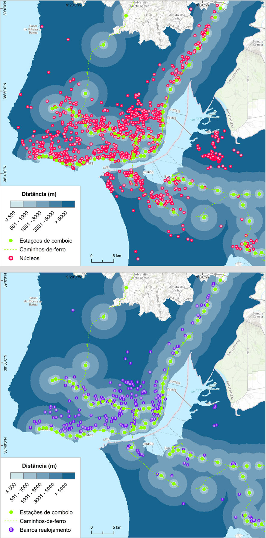
Likewise, 33% of settlements were more than 3km away from a hospital, while only
25% of estates now are. The latter is partly explained by the good hospital coverage
across the LMA, so regardless of where people live they are always near a hospital (see
PER Atlas/outros elementos/hospitais). Notwithstanding, in municipalities such as
Cascais, Oeiras, Loures and Barreiro the data points to increasing peripheralization.
Our next steps involve analyzing this proportionally, so we could end up with different
patterns, but in any case looking at rehousing through this perspective clearly nuances
the negative effects of displacement.

The final indicator we wish to show here concerns the ethnic and racial composition of
the populations. Although highly controversial, the issue of the ethno-racial origin of a
large percentage of individuals who were rehoused by the PER should be addressed.
On the one hand, the PER was the first public housing program to integrate immigrants
as eligible individuals. On the other, many researchers or public intellectuals point to a hidden but persistent element whereby black populations were displaced from their
settlements more forcefully than white populations (see Alves 2019).

The map above shows the 50 most populated settlements and the percentage of
households whose head was a national of one of the five Portuguese-speaking
countries (PALOPs), thus including their spouses and descendants. This simple
indicator is an approximation to the 'Africans and Afro-descendants' informal social
category that has ‘black skin’ for implicit. We created it because the Portuguese
Census does not collect data on 'racial' features such as skin color. Our indicator is thus
not a perfect indicator (a mother and a father may for example have Angolan
nationality and be white, and their children too, so the 'racialized' factor would
disappear), but our own first-hand experience tells us such exceptions were residual in
the PER. This indicator is therefore relatively reliable and important for analyzing the
PER in its ethno-racial dimension.
The map shows that the more multicultural, multi-ethnic and black settlements were located in the suburban ring, not in Lisbon. In the city the settlements were predominantly white. We are still working on further indicators to shed light into this history (such as whether black households had longer or more dispersed rehousing paths), we will publish them here as soon as we analyse them.
All in all, the displacement of people across urban space was an integral element of the PER and the broader process of urban restructuring of the Lisbon Metropolitan Area of which it was a small but key part. In many cases where the PER was involved, regenerating and re-planning the urban territory (“requalificar o território” [Mayor, Sep 2019]) meant that the clearance of shanty towns was not followed by in situ rehousing but rather by developments for richer populations or for infrastructure. Even when that was not the case, not everyone living in a particular settlement could benefit from staying close to jobs and social networks.
The logic of dispersal of the urban poor across the metropolitan area prevailed, and for these populations it was an experience of major disruption, involving a) the uprooting and splintering of communities, b) the displacement to sites several kilometres away, and c) a re-insertion into areas with fellow previous slum dwellers from many different origins, essentially areas with a high concentration of poverty.
The differences between municipalities’ implementation models show that this was not a univocal process, it had many nuances, but the overall patterns are clear. As López-Morales (2011) and López-Morales et al (2019) have shown, housing policies and programs can have unintended or unexpected overflows which exacerbate rent gaps in informal areas in the process of being renewed. Rapid processes of commodification of urban land then lead to the displacement of incumbent populations in favor of large-scale developers. Perhaps not perfectly, but the description fits well with the PER.
We will update this page as we produce more analysis from our cartography.
The map shows that the more multicultural, multi-ethnic and black settlements were located in the suburban ring, not in Lisbon. In the city the settlements were predominantly white. We are still working on further indicators to shed light into this history (such as whether black households had longer or more dispersed rehousing paths), we will publish them here as soon as we analyse them.
*
All in all, the displacement of people across urban space was an integral element of the PER and the broader process of urban restructuring of the Lisbon Metropolitan Area of which it was a small but key part. In many cases where the PER was involved, regenerating and re-planning the urban territory (“requalificar o território” [Mayor, Sep 2019]) meant that the clearance of shanty towns was not followed by in situ rehousing but rather by developments for richer populations or for infrastructure. Even when that was not the case, not everyone living in a particular settlement could benefit from staying close to jobs and social networks.
The logic of dispersal of the urban poor across the metropolitan area prevailed, and for these populations it was an experience of major disruption, involving a) the uprooting and splintering of communities, b) the displacement to sites several kilometres away, and c) a re-insertion into areas with fellow previous slum dwellers from many different origins, essentially areas with a high concentration of poverty.
The differences between municipalities’ implementation models show that this was not a univocal process, it had many nuances, but the overall patterns are clear. As López-Morales (2011) and López-Morales et al (2019) have shown, housing policies and programs can have unintended or unexpected overflows which exacerbate rent gaps in informal areas in the process of being renewed. Rapid processes of commodification of urban land then lead to the displacement of incumbent populations in favor of large-scale developers. Perhaps not perfectly, but the description fits well with the PER.
We will update this page as we produce more analysis from our cartography.
1.The numerical relevance of the dwelling units built by the PER in relation to the total of public housing
in Portugal is significant, representing over a third of the entire public housing stock in the country,
which is estimated at around 120,000 dwellings (Santos et al 2014; IHRU 2015b).
2.Data was collected and reworked by Ana Ferreira, Alessandro Colombo, Ana Estevens, Cinzia Sofia and Miguel Leal. Many thanks to them.
REFERENCES
AML – Área Metropolitana de Lisboa (1997). Caracterização do Programa Especial de Realojamento na Área Metropolitana de Lisboa, Lisboa, AML.
Alves, A. R. (2019). “Para eles, nós não somos humanos!”: habitação, território e a monitorização de violências racializadas em Portugal. Revista Direito e Práxis, 10(3), 2068-2096.
Ascensão, E. (2015). Slum gentrification in Lisbon, Portugal: displacement and the imagined futures of an informal settlement. In Lees, L., Shin, H.B. and López-Morales, E. (eds.) Global Gentrifications: Uneven development and displacement. Bristol: Policy Press, pp. 37-58.
Cachado, R. Á. (2013) O registo escondido num bairro em processo de realojamento: o caso dos hindus da Quinta da Vitória. Etnográfica, 17/3, 477-499.
CET (1992) Levantamento e Caracterização Urbanística dos Bairros de Barracas do Concelho de Loures (CET report n. 12). Lisboa: CET.
Chaves, M. (1999) Casal Ventoso: da gandaia ao narcotráfico – marginalidade económica e dominação simbólica em Lisboa, Lisboa, Instituto de Ciências Sociais.
Cocola-Gant, A. and Gago, A. (2019) Airbnb, buy-to-let investment and tourism-driven displacement. A case study in Lisbon. Environment and Planning A: Economy and Space. DOI: https://doi.org/10.1177/0308518X19869012.
Freitas, M. J. (1994) Os paradoxos do realojamento, Sociedade e território, 20, 26-35. IHRU (2015b). Information request to national housing institute (Instituto da Habitação e da Reabilitação Urbana), July 2015.
LNEC (1995) Bairro das Marianas. Pré-Diagnóstico. Relatório 354/95. Lisboa: LNEC. López-Morales, E. (2011) Gentrification by Ground Rent Dispossession: The Shadows Cast by Large-Scale Urban Renewal in Santiago de Chile, International Journal of Urban and Regional Research, 35.2, 330–57.
López-Morales, E., Sanhueza, C., Espinoza, S., Ordenes, F., and Orozco, H. (2019). Rent gap formation due to public infrastructure and planning policies: An analysis of Greater Santiago, Chile, 2008–2011. Environment and Planning A: Economy and Space, DOI: https://10.1177/0308518X19852639.
Malheiros, J. M. and Vala, F. (2004) Immigration and city change: the region of Lisbon in the turn of the 20th century, Journal of Ethnic and Migration Studies, 30/6, 1065- 1086.
Marques, M. M., Santos, R., Araújo, F. and Nóbrega, S. (2001) Realojamento no Concelho de Oeiras: um estudo sociológico. Oeiras: CMO.
Montezuma, J. and McGarrigle, J. (2019) What motivates international homebuyers? Investor to lifestyle ‘migrants’ in a tourist city, Tourism Geographies, 21-2, 214-234.
Nunes, J. A. and Serra, N. (2004), Decent housing for the people: urban movements and emancipation in Portugal, South European Society Politics, 9-2, 46-76.
Pincha, J. (2019) Terrenos da antiga Pedreira dos Húngaros vão a leilão por 14 milhões, Público, 27/3/2019.
Pinto, P. R. (2009), Housing and citizenship: building social rights in twentieth century Portugal, Contemporary European History, 18-2, 199-215.
Pinto, T. C. (1994) A Apropriação do Espaço em Bairros Sociais: o gosto pela casa e o desgosto pelo bairro, Sociedade e território, 20, 36-43.
Pozzi, G. (2017) Cronache dell’abitare. Pratiche di costruzione informale e rialloggiamento forzato nel quartiere Santa Filomena (Lisbona). Antropologia, 4/1, 49- 69.
Rodrigues, C. M. (1989), Eficiência e equidade na produção de espaço clandestino, in Gaspar, J. (ed.), Clandestinos em Portugal – Leituras, Lisboa, Livros Horizonte.
Salgueiro, T. B. (1977), Bairros clandestinos na periferia de Lisboa, Finisterra - Revista portuguesa de geografia, XII – 23, 28-55.
Sampaio, C. (2013), Habitar o 6 de Maio: as casas, os homens, o bairro, MSc dissertation, ICS-ULisboa.
Santos, A. C., Teles, N. and Serra, N. (2014). Finança e Habitação em Portugal. Coimbra, Centro de Estudos Sociais.
Suggested citation: Ascensão, E. and Leal, M., Spatial Analysis, research http://expertsproject.ics.ulisboa.pt/analise.html , (last accessed on day/month/year).